On Thursday, Oct. 29, at 6 p.m., the Jupiter Town Council takes its first vote on the Sperry property. That's 10.5 acres at 961 and 997 North A1A in Inlet Village, where the owners want to build a hotel, condominiums, a restaurant, shops and a marina. Jupiter News Now reports that town planners call it one of the last large undeveloped parcels in the town's Community Redevelopment Agency area.
Most of the coverage will be about the hotel and the marina. For anyone who walks or bikes the Riverwalk, a smaller number matters more. The council already settled most of the public features on this site in 2023. The one public feature still undecided is a 393-foot stretch of planned waterfront path.
What Sits On The Site Today
Many Jupiter residents know this property by its tenants. The town's staff report lists a commercial building that holds Blueline and Cones and Coffee, along with a parking lot, an apartment building and a dock. Two decades ago it was something else. In 2003 the site was the Suni Sands mobile home park.
The parcel is on the north side of North A1A, east of Clemons Street. If you've stopped there after a paddle or for a cone on the way to the inlet, you've been on the land this vote is about.
What The Council Already Locked In, In 2023
The site also holds the Suni Sands shell midden, which the town's plan lists as a place of historical and archaeological significance. In 2023 the Town Council required the 4.07-acre midden to be preserved with a 10-foot buffer. The same decision required that two other features stay in place, the old Celestial Railway right-of-way and a view corridor in the northwest corner.
That right-of-way goes back to one of Jupiter's odder chapters. The town's own history of the line describes the Jupiter and Lake Worth Railway as a 7.5-mile narrow-gauge line between Juno and Jupiter. It was announced on June 8, 1887, and its engine reached Jupiter by steamboat in March 1889. A writer called it the "Celestial Railroad" in 1893. Flagler's railroad then bypassed Jupiter, the line went into decline, and it was sold at auction in June 1896.
The owners' current request would put the land under the midden and that northwest corner into a Conservation land use. Town staff called that "an important level of protection," Jupiter News Now reported.
So the history stays on this site under every version now before the council. The open question is the shoreline.
Where The 393 Feet Fit Into The Riverwalk
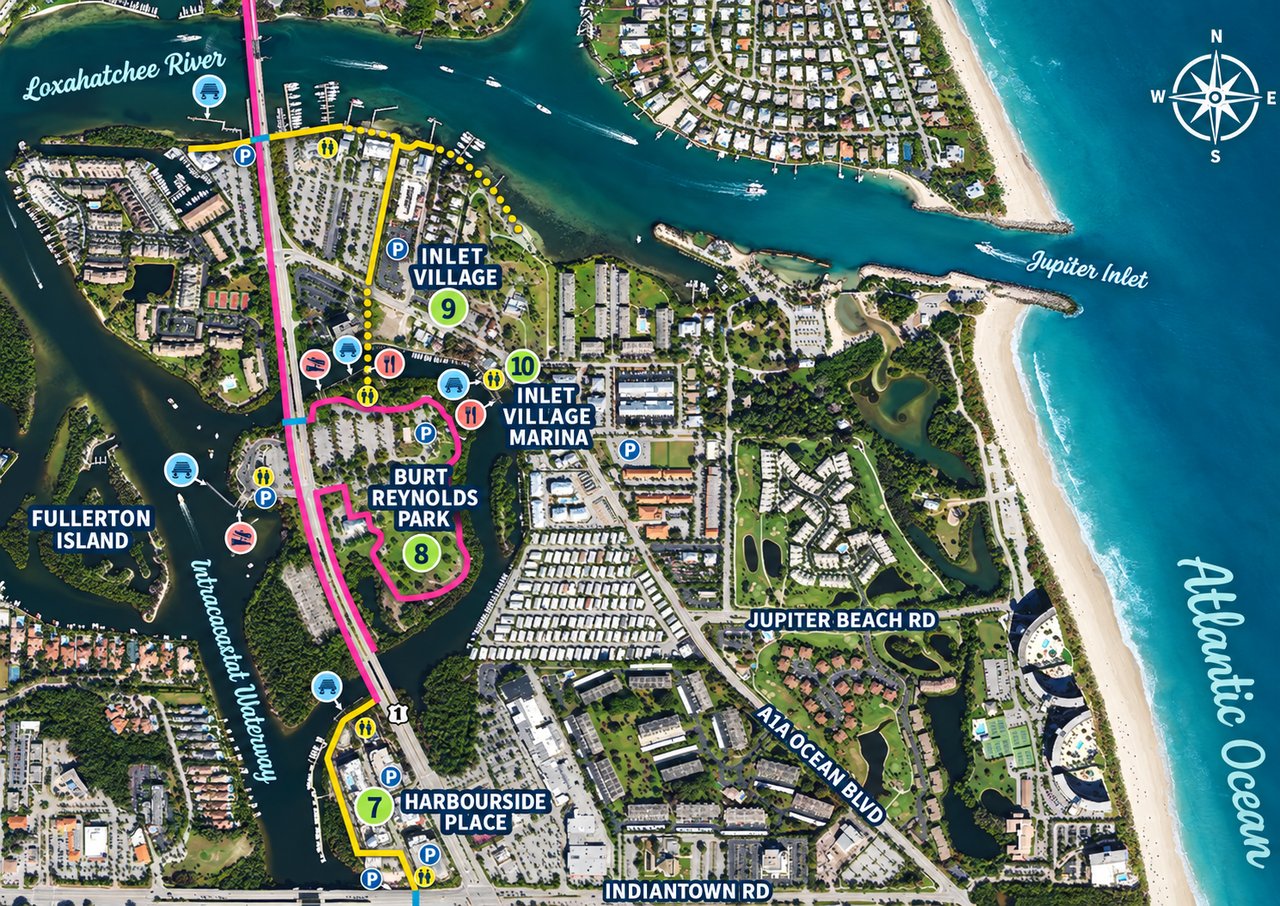
The Riverwalk runs along the eastern shore of the Intracoastal from Jupiter Ridge Natural Area north to the Jupiter Inlet. When it's finished it will be about 2.5 miles of 15-foot-wide path for walkers and cyclists. It's also part of the East Coast Greenway. That 2.5 miles is the length planned for the finished path, not what is built today.
The Jupiter News Now trails guide lists the stops from south to north:
- Ocean Way
- Jupiter Ridge
- Mangrove Bay and the Lagoon Bridge
- Plaza Down Under at the Indiantown Road bridge
- Harbourside Place
- Burt Reynolds Park
- Inlet Village and the Lighthouse Promenade
The Sperry property is at the Inlet Village end of that list. The plan has been to carry the Riverwalk along this shore to the historic Sperry boathouse. The boathouse came down in 2016 after hurricane damage, according to the staff report.
The owners want the Riverwalk corridor on their site to end near the dock at the northwest corner. That would shorten it from 535 feet to 142 feet, a cut of 393 feet. Town staff did not take a side. In the words reported by Jupiter News Now, staff called the change a
"policy decision of the Town Council."
Staff also noted what goes with it. Shortening the corridor would drop the requirement for future public access along part of the waterfront.
So the length of the corridor decides whether the public can reach that part of the shore at all, years from now, once the site is built.
Two Versions Of The Same Site
On Sept. 10, the Planning and Zoning Commission reviewed the request and recommended a different version. According to its meeting synopsis, the vote was 7-0. An earlier motion to approve the owners' version failed for lack of a second.
Owners' request | Planning and Zoning recommendation | |
|---|---|---|
Riverwalk Corridor on site | 142 feet | 535 feet, the full length |
Inlet Village Flex, mixed use | 5 acres | 4.3 acres |
Conservation | 5.5 acres | 6.2 acres |
Traffic | Trip cap recommended by staff | Council asked to consider traffic mitigation and an "equitable trip cap" |
The commission's version moves about 0.7 acre along the shoreline into Conservation. That's the same strip where the Riverwalk would run. Its recommendation is advice to the council, which makes the decision.
On Oct. 29 the council has three items on the site, each on first reading:
- A land use change. It covers the Flex and Conservation split and the length of the Riverwalk Corridor (town notice).
- A zoning text change. It would allow Inlet Village Flex South zoning on land north of North A1A between Clemons Street and Saturn Street (town notice).
- A planned unit development. This is the hotel, condo, restaurant, retail and marina plan, with several waivers from town rules.
The Traffic Number Behind The Trip Cap
The town wants North A1A to stay a two-lane road through Inlet Village, so staff recommended capping the number of car trips the site can generate. Table 2 of the staff report sets the maximum under each land use against the town's planning allocation for this parcel.
Scenario | Daily trips | Evening peak hour trips |
|---|---|---|
Today's land use, at its maximum | 2,950 | 272 |
Requested land use, at its maximum | 3,505 | 327 |
Town's A1A planning allocation for the site | 1,926 | 233 |
Even the current land use, built out to its maximum, would allow about 1,000 more daily trips than the town has set aside for this parcel. The request would raise the ceiling by another 555. The applicant's traffic study found that nearby roads meet the town's traffic standards through 2045. Staff said the request could still exceed the town's goal for A1A, and that's why it suggested the cap.
One number goes down under the request. The most homes the site could hold would fall from 73 to 59, the report says, mostly because of the Conservation land.
If you drive North A1A toward the inlet or DuBois Park, the trip cap is the part of this vote you'll notice most once the site is built. For people on foot or on a bike, it's the corridor length.
How To Follow It From Here
The council meets at 6 p.m. on Thursday, Oct. 29, in the Council Chambers at 210 Military Trail. It hears public comment for and against at that hearing.
- Agenda and documents: The town usually posts these about a week before the meeting on its agendas page, so they may be up by the time you read this.
- Questions before the meeting: The town's notice names planner Peter Meyer in the Planning and Zoning Department, 561-741-2691.
- After Oct. 29: A second reading, with the site plan, will come at a meeting the town has not yet scheduled.
A first-reading vote is not the final word. Whatever the council decides on Oct. 29, the plan returns for a second reading, this time with the site plan attached.
I follow decisions like this one because they shape the everyday Jupiter my clients ask me about, from where the Riverwalk ends to how North A1A feels at 5 p.m. If you'd like to talk through what the Inlet Village changes could mean for your corner of town, Kristin Wallace is glad to help. Let's Connect.